Railway in beeston
-
The Parksider
- Posts: 1581
- Joined: Sat 10 Nov, 2007 3:55 am
Phill_dvsn wrote: Nice one Russ Most of the line has been built on in South Leeds, but you can still make it out on Google earth, The Tingley viaduct is still intact that the line used.Pictures of the line around Dewsbury road towads Morley can be seen in this section of Lost rails.http://www.lostrailwayswestyorkshire.co ... eeston.htm I first saw this line when I was 14 and had a walk in the area with my mum and auntie. I had my camera and took a picture of the line's bridge over the miggy railway and the miggy light railway (tramway) which I have. I also had (it is mising but will be somewhere) a picture of the "cuckoo steps" that were pedestrain bridge steps over the line just east of new pit.At one time the YEP ran an argument about the cuckoo steps. My dad said it was the ones at new pit/parkside, someone said it was crossing steps at stourton and I found the stone steps next to the terrace of houses at woodhouse hill (they overlook the MI today which follows the line at that point) on a map marked cuckoo steps.I wish I had the ability to upload stuff like some of you and DO NOT say "oh it's easy"!!!
-
Trojan
- Posts: 1990
- Joined: Sat 22 Dec, 2007 3:54 pm
The Parksider wrote: Phill_dvsn wrote: Nice one Russ Most of the line has been built on in South Leeds, but you can still make it out on Google earth, The Tingley viaduct is still intact that the line used.Pictures of the line around Dewsbury road towads Morley can be seen in this section of Lost rails.http://www.lostrailwayswestyorkshire.co ... eeston.htm I first saw this line when I was 14 and had a walk in the area with my mum and auntie. I had my camera and took a picture of the line's bridge over the miggy railway and the miggy light railway (tramway) which I have. I also had (it is mising but will be somewhere) a picture of the "cuckoo steps" that were pedestrain bridge steps over the line just east of new pit.At one time the YEP ran an argument about the cuckoo steps. My dad said it was the ones at new pit/parkside, someone said it was crossing steps at stourton and I found the stone steps next to the terrace of houses at woodhouse hill (they overlook the MI today which follows the line at that point) on a map marked cuckoo steps.I wish I had the ability to upload stuff like some of you and DO NOT say "oh it's easy"!!! oh it's easy
Industria Omnia Vincit
-
Barwicker
- Posts: 147
- Joined: Tue 10 Apr, 2007 11:27 am
Phill_dvsn wrote: chameleon wrote: dervish99 wrote: Hi I was wondering if anyone new anything about the old railway line which ran from the bottom on Middleton Woods , to the far end of Derwsbury Road, near the White rose center. It roughly follows the line of Dewsburr Road, hopefully i can attatch a map to this with it's outline on. i used to play as a kid in this section until it was filled in sometime in the mid 80's.ThanksRuss Don't seem to be able to upload a pic from Google maps, may be the uni server blocking the upload?? This has come up before - Phill can you for one help here? I can indeed. It used to be the 'Great Northern Railway' Beeston Junction to Hunslet Goods line until it closed in 1967. The line is still intact from Neville Hill, It winds down hill through Cross green to the road stone facility at Knowsthorpe. The line then used to cross the River Aire over the huge swing bridge featured on S.L before.Buffer stops are now in place at the severed bridge over the river, any trace of the line from that point towards Beeston has long since gone. There the line ran across Wakefield road (the railway bridge remains can still be seen here) Then it crossed (and had a connection with) the Middleton railway before travelling through Beeston towards Tingley and Morley.There are some pictures and maps of the line here (sadly there isn't much around the Tommy Wass/Beeston area.http://www.lostrailwayswestyorkshire.co ... %20gds.htm I visited the annual exhibition of the Normanton & Pontefract Model Railway Society in Pontefract on Sunday and was very pleased to be able to buy a copy of "The Great Northern Railway in the West Riding" by Martin Bairstow, published in 1999. This gives the history of many of the former GNR branch lines including the one from Beeston to Batley and also the Pudsey Loop which has been discussed on S/L earlier. There are pictures of both Beeston Junction and Beeston Station. The Batley line closed to passengers in October 1951.I agree with most of the message above but do not think there was much connection between the Hunslet Goods Line and the Beeston to Batley Line. I imagine most of the traffic off the Hunslet Goods line would be taken to Ardsley sidings for sorting and onward shipment
-
Phill_dvsn
- Posts: 4423
- Joined: Wed 21 Feb, 2007 5:47 am
I wonder if this answers Parksiders earlier question about the short branch towards the river?There were three coal loading staithes on the river Aire.You can still see the Waterloo colliery pit staithe more or less opposite Hunslet mills on the opposite side of the river, it is very overgrown these days though.It ran from Waterloo colliery and crossed under a bridge carrying the Neville hill-Beeston branch just past the sidings at Hunslet goods yard.The oldest coal staithe from the Waterloo pit was this wooden jetty type affair here. I'm wondering if this is what Parksider means?http://snipurl.com/u9f1tYou can still see the stonework survives to this day a litte past this massive swing bridge pier herehttp://www.lostrailwayswestyorkshire.co.uk/ima ... ire.jpgThe other coal staithe was on the other side of the river from the Middleton pit, that stonework also survives, but i think that hadn't been used for donkeys years. I've only seen it mentioned on very old maps before.It's inbetween the big swing bridge and the canal and river jnct.There are some good pics and maps of the railway in that area herehttp://www.lostrailwayswestyorkshire.co.uk/Bee ... %20gds.htm This is a pretty good detailed map of the railway in that area, it only shows one of the coal staithes though, but it does show us the river Aire used to run in an older channel in that area too.http://www.lostrailwayswestyorkshire.co ... 0Leeds.jpg
My flickr pictures are herehttp://www.flickr.com/photos/phill_dvsn/Because lunacy was the influence for an album. It goes without saying that an album about lunacy will breed a lunatics obsessions with an album - The Dark side of the moon!
-
Barwicker
- Posts: 147
- Joined: Tue 10 Apr, 2007 11:27 am
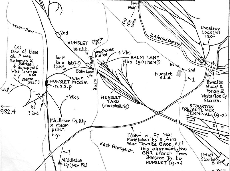
Further to the above, at yet another Model Railway Show I saw and took a photograph of a map showing past and present Railway Lines in the Middleton & Hunslet areas. This includes wagonways dating back to 1755 but is not fully detailed. This was with the consent of the stallholder.If Phil would care to contact me off S/L with his email address I will gladly send a copy direct. I think this may also be of interest to Parksider. But please be quick as I vanish for about a month early next week.
-
Phill_dvsn
- Posts: 4423
- Joined: Wed 21 Feb, 2007 5:47 am
Thanks Barwicker, that would be great.I have my e-mail address visible on all my sites, including S.L i think.So i don't mind giving you it herephill_dvsn@yahoo.co.ukCheers p
My flickr pictures are herehttp://www.flickr.com/photos/phill_dvsn/Because lunacy was the influence for an album. It goes without saying that an album about lunacy will breed a lunatics obsessions with an album - The Dark side of the moon!
-
dogduke
- Posts: 1407
- Joined: Thu 03 Jan, 2008 6:47 am
Re Barwicker's post I imagine most of the traffic off the Hunslet Goods line would be taken to Ardsley sidings for sorting and onward shipment..In my time Hunslet East was a 'Full loads depot'nothing less than a wagon load for one consignee,most of the traffic did go via Ardsleyfor shunting out for trunk services.The Neville Hill connection prior to the oil trains was I think mainly forsteel from the north east and the return empties.Hunslet Lane and Wellington street handled some full loads but was mainly 'sundries'traffic,odd lots for different consignees for a single destination or for forward tranhipment if a daily wagon was not viable.The warehouses were set up with wagons for various destinationsin such a way that it minimised shunting at the next yard.Wellington Street used to 'perambulate'road vehicles in a linediscarging into appropriate wagon as they passed.At Hunslet Lane lorries discharged and goods were barrowed to the correct van.This 'sundries traffic'was long ago identified as a loss maker and was I think the first ever rail privatisation 196x.National Carriers was born and became part of the NationalFreight Corporation.Rakusens used the warehouse facilities,and BR used to distributebagged cement,Drikold and lots of stuff for various businesses.Such a long time ago
Consciousness: That annoying time between naps.90% of being smart is knowing what you're dumb at.
-
The Parksider
- Posts: 1581
- Joined: Sat 10 Nov, 2007 3:55 am
Barwicker wrote: Further to the above, at yet another Model Railway Show I saw and took a photograph of a map showing past and present Railway Lines in the Middleton & Hunslet areas. This includes wagonways dating back to 1755 but is not fully detailed. This was with the consent of the stallholder.If Phil would care to contact me off S/L with his email address I will gladly send a copy direct. I think this may also be of interest to Parksider. But please be quick as I vanish for about a month early next week. That's a kind thought.I came across the waggonways map in the "coal mining in Middleton" tome. Indeed I went to the park and walked them.One runs from the broom site up through Miggy Wood as a pathway today, but an original feature in terms of a "cutting" is still there loud and clear. A small feature that is a remnant of a pre "oldest railway in the world" railway!!