Page 1 of 2
St. Peter's Street/Duke Street.
Posted: Wed 02 Jun, 2021 9:05 pm
by Leodian
I'm confused (easily done

) as to what road is correctly called St. Peter's Street or Duke Street by the Leeds Bus Station, as they may or may not be interchangeable names when I look at maps of Leeds. Perhaps just using A61 may be the best for there!
Re: St. Peter's Street/Duke Street.
Posted: Wed 02 Jun, 2021 10:24 pm
by buffaloskinner
I cannot fathom what maps you are looking at that are confusing you but St Peters Street runs from Eastgate in front of bus station to St Peters Square and Duke Street runs from St Peters Square under the railway bridge to Marsh Lane.
Re: St. Peter's Street/Duke Street.
Posted: Wed 02 Jun, 2021 10:27 pm
by chemimike
Looks like the carriageway going towards the centre is St Peters St, as is the carriageway going out from Eastgate to the junction with St Peters Square.
However the cariaigeway out from St Peters Square is Duke St Seems like the Mad Hatter spent some time in the planning department
- ScreenHunter 2805.jpg (399.47 KiB) Viewed 2181 times
Re: St. Peter's Street/Duke Street.
Posted: Wed 02 Jun, 2021 10:28 pm
by chemimike
chemimike wrote: ↑Wed 02 Jun, 2021 10:27 pm
Looks like the carriageway going towards the centre is St Peters St, as is the carriageway going out from Eastgate to the junction with St Peters Square.
However the cariaigeway out from St Peters Square is Duke St.
Seems like the Mad Hatter spent some time in the planning department
ScreenHunter 2805.jpg
Re: St. Peter's Street/Duke Street.
Posted: Wed 02 Jun, 2021 11:18 pm
by Leodian
buffaloskinner wrote: ↑Wed 02 Jun, 2021 10:24 pm
I cannot fathom what maps you are looking at that are confusing you but St Peters Street runs from Eastgate in front of bus station to St Peters Square and Duke Street runs from St Peters Square under the railway bridge to Marsh Lane.
Hi buffaloskinner.
My confusion is that some maps I've seen only state St. Peter's Street while others only state Duke Street, but some are uncertain where each is and/or how far each goes.

Re: St. Peter's Street/Duke Street.
Posted: Wed 02 Jun, 2021 11:28 pm
by Leodian
chemimike wrote: ↑Wed 02 Jun, 2021 10:27 pm
Looks like the carriageway going towards the centre is St Peters St, as is the carriageway going out from Eastgate to the junction with St Peters Square.
However the cariaigeway out from St Peters Square is Duke St Seems like the Mad Hatter spent some time in the planning department
ScreenHunter 2805.jpg
Hi chemimike.Thanks for your help.
The actual stretch covered by each name will likely add to the possible confusion of any motorists using that area! I wonder what sat navs have?
Re: St. Peter's Street/Duke Street.
Posted: Thu 03 Jun, 2021 8:55 am
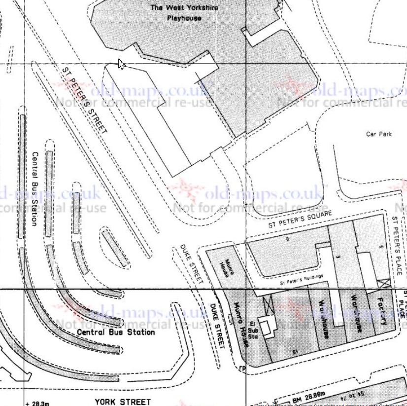
by buffaloskinner
Then this 1964 OS map should explain it better for you
Re: St. Peter's Street/Duke Street.
Posted: Thu 03 Jun, 2021 6:48 pm
by tyke bhoy
Even more confusion with Chemimike's map. Surely a composite with that bus station configuration and the presence of the west yorkshire playhouse opposite at least 20 years apart?
Re: St. Peter's Street/Duke Street.
Posted: Fri 04 Jun, 2021 1:25 pm
by chemimike
The map I posted is dated as 1988-90
Re: St. Peter's Street/Duke Street.
Posted: Fri 04 Jun, 2021 8:14 pm
by Leodian
Thanks all for your help
. I now know more about St. Peter's Street and Duke Street than I did.
PS. Other maps show just how short length that Dyer Street is! It hardly seems worth retaining its long-time name!
