Page 1 of 2
Manston Signalbox
Posted: Sun 06 Mar, 2016 8:44 pm
by andrewmawson
Does anyone know exactly where (a) the Manston Signalbox used to be (yes, I know it was in Manston) and (b) where Manston Siding used to be? It turns out my Great Grandfather was a signalman there and lived in a cottage on Manston Siding. I can't find any evidence of either.
Re: Manston Signalbox
Posted: Sun 06 Mar, 2016 10:38 pm
by warringtonrhino
Years ago I was commissioned to do a large plan of the Manston Colliery based on a set of smaller works plans. I have attached a copy.
The wagon-way shown on the plan was a railway with sidings at two pits, the signal box was at the junction with the main line and Manston station was further east.
To make the file small enough to fit the limits of our system I have had to reduced the size - which also reduces the quality.
Re: Manston Signalbox
Posted: Sun 06 Mar, 2016 10:55 pm
by liits
Here are couple of pics of Manston Cottages from Leodis,
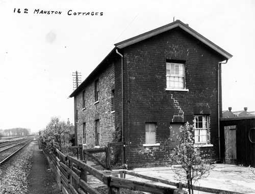
- Manston Cottage1.jpg (31.45 KiB) Viewed 9350 times

- Manston Cottage 2.jpg (27.46 KiB) Viewed 9350 times
and a map of where they were which also shows the signal box.

- Manston Map.jpg (935.11 KiB) Viewed 9350 times
Presumably the signal box controlled the points of the junction for the line running up to the pit and coal yard where the Arndale is now.
Re: Manston Signalbox
Posted: Sun 06 Mar, 2016 11:14 pm
by liits
As an afterthought.....
I wonder how the residents of the cottages gained access to them. I guess that in the days before the factory was built, it would have been along Manston Lane and across the fields - although no footpath is marked on the map, but what about after the factory was built? The test track wasn't always there and even when it was, it was gated off from the factory as a separate piece of land, was there access across the test track with a gate in the fence or was there a path along side the track [all the way to the bridge at Austhorpe Road / Lane [and that would have involved crossing the spur running into the factory]?
Re: Manston Signalbox
Posted: Mon 07 Mar, 2016 10:27 am
by buffaloskinner
Liits access to the signal box and cottages was via a footpath which ran parallel to the rail line from Austhorpe Road.
Strangely enough the signal box at the top of Sutton Approach was operated by someone I knew, and in the early 50s I and my friends spent many an happy hour in the box pulling the levers and waving to the trains.
Just remembered the best bit of being in the signal box was getting the detonators out for putting on the track for fog warning. Shame he wouldn't let us put them on the track.
Re: Manston Signalbox
Posted: Mon 07 Mar, 2016 9:29 pm
by liits
Thanks for that, buffaloskinner. Looking on Google Earth there is still a gate in the fence beside the bridge. Albeit the gate and fence are modern, its nice to see that Notwork Rail have maintained their access point.

- Barnbow footpath.jpg (196.16 KiB) Viewed 9272 times
Re: Manston Signalbox
Posted: Tue 08 Mar, 2016 11:56 pm
by The Parksider
warringtonrhino wrote:Years ago I was commissioned to do a large plan of the Manston Colliery based on a set of smaller works plans. I have attached a copy.
The wagon-way shown on the plan was a railway with sidings at two pits, the signal box was at the junction with the main line and Manston station was further east.
To make the file small enough to fit the limits of our system I have had to reduced the size - which also reduces the quality.
Brilliant
Is Catherine Pit the name of the pit still existent on Farm Road.
Oft marked as "old shaft" it is unusual to survive in it's original abandoned state?
Re: Manston Signalbox
Posted: Wed 09 Mar, 2016 1:19 am
by Leodian
Yes the map provided by warringtonrhino is fascinating.

There are a lot of pits in the small area! The Mt Hermon Pit name intrigues me.
Re: Manston Signalbox
Posted: Wed 09 Mar, 2016 9:05 am
by warringtonrhino
For years I have been working on the history of 'my' Seacroft.
This is a very small section of the master plan, which only displays the current roads and buildings, the railway, the extent of my area of interest(black line) and some of the minerals in that area. Most of the other details are 'switched off' to reduce the file size. Converting it from a CAD drawing to a jpg file also reduced the quality, but hopefully you can make out the details. The old coal pits are red circles and all are named. As you can see my area of interest does not extend to the Manston colliery, but I have collected some of that information which could be scanned and published if required?
Re: Manston Signalbox
Posted: Thu 17 Mar, 2016 2:52 am
by andrewmawson
warringtonrhino wrote:Years ago I was commissioned to do a large plan of the Manston Colliery based on a set of smaller works plans. I have attached a copy.
The wagon-way shown on the plan was a railway with sidings at two pits, the signal box was at the junction with the main line and Manston station was further east.
To make the file small enough to fit the limits of our system I have had to reduced the size - which also reduces the quality.
This is fantastic - thank you so much for posting -it really helps put the picture together.