Page 1 of 2
Posted: Tue 31 Jan, 2012 6:53 pm
by Jogon
I came across this by accident, a building in the background of an old (philld) shot of the wrens pub.
http://www.leodis.org/display.aspx?reso ... LAY=FULLIt looked very beautiful. A row of black and white 'Tudor' style shops, the name taken from the main occupant, Rothwells Furniture Shop. Built by the wealthy Lupton Family (who also built the Grand Arcade).It stars on the cover of 'Aspects of Leeds 3' ISBN 1-903425-05-0It appears to have been across New Briggate from the Chest Clinic (Richer Sounds).Specifically over Cross Belgrave St from the Wrens, and fronting New Briggate to where Vicar Ln links up and it becomes North St.To the right of this google map diagonally dissected by North St.
http://maps.google.co.uk/maps?q=New+Bri ... 270&z=19It was just where the inner ring road was going and was demolished in the 1960's.Don't know if this has been covered before.Any more information and/or images?I'm not very good at posting images but will try with one found on the web
Posted: Tue 31 Jan, 2012 10:56 pm
by buffaloskinner
These the ones you mean? All very elegant
Posted: Wed 01 Feb, 2012 1:55 am
by Cardiarms
Tha's progress!Nowdays they'd keep them.
Re:
Posted: Mon 07 Mar, 2016 10:09 am
by blackprince
Cardiarms wrote:Tha's progress!Nowdays they'd keep them.
Sadly I don't remember this elegant terrace or the shops in the photo. I must have been an unobservant lad. It looks as good as parts of Chester.
In a similar situation in Manchester when the Arndale Centre was built they moved a half timbered building ( Sinclair's Oyster Bar) to a new location in the new complex. I remember Leeds at the time , mid to late 60's , was in a frenzy of demolition. The whole area between the University and Westgate, for example, resembled a bombed out city with huge piles of rubble for several years.
A couple of questions : The car behind the green bus maybe a Triumph Vitesse? I do remember the large street lamps which were suspended by wires over the middle of the road like the one in the 3rd photo . Any idea when these were replaced by more conventional street lighting in the city centre?
Re: Rothwell's Parade, New Briggate
Posted: Mon 07 Mar, 2016 1:15 pm
by volvojack
Black Prince's reference to a "Bomb Site" reminded me of when I walked to town from North St each day in the early 1960's I became aware of this huge crater extremely deep with men working down there with lots of steel, pipes etc. This was somewhere in the vicinity of the old Dispensary and I could not understand what it could possibly be. of course it was the early days of the Inner Ring Road being constructed .
Re: Rothwell's Parade, New Briggate
Posted: Mon 07 Mar, 2016 2:59 pm
by tyke bhoy
Re: Rothwell's Parade, New Briggate
Posted: Mon 07 Mar, 2016 3:22 pm
by TABBYCAT
@Blackprince.
Not a Vitesse but I'm 99% sure it's a a TR4 or5
Re: Rothwell's Parade, New Briggate
Posted: Mon 07 Mar, 2016 3:32 pm
by Leodian
I thought it may help to show the location of what I think will have been Rothwell's Parade. These 2 maps are taken from the Old Maps UK (OMUK) website. The first is a section of a 1954-1969 1:1250 map in OMUK and shows the parade of premises in about the centre of the map. The second is a section of a 1962-1990 1:1250 map in OMUK and shows an empty space where the row of premises (and other features) is no longer there. Sorry for the large amount of space in the maps as I've forgotten how I used to be able copy and save without the space!
Like blackprince I also do not recall the row of premises, but I should be able to do. Though it would have been an area that I rarely got right up to I would have gone to the nearby Ritz (later ABC) and Tower Cinemas so I must have seen the row. It's a shame that I cannot recall them.
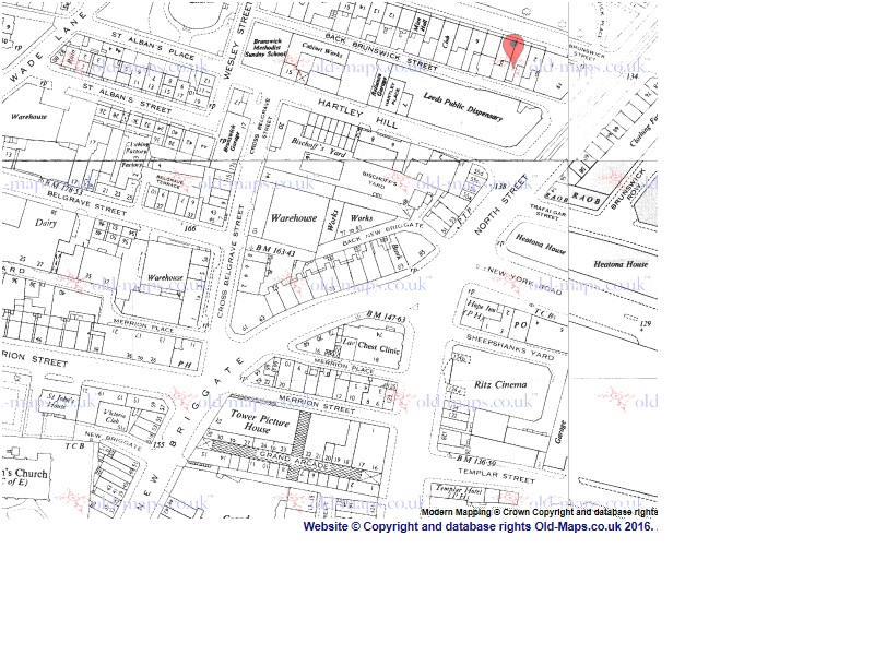
- From a 1954-1969 map in the Old Maps UK website.
- OMUK1954-1969.jpg (169.69 KiB) Viewed 6056 times
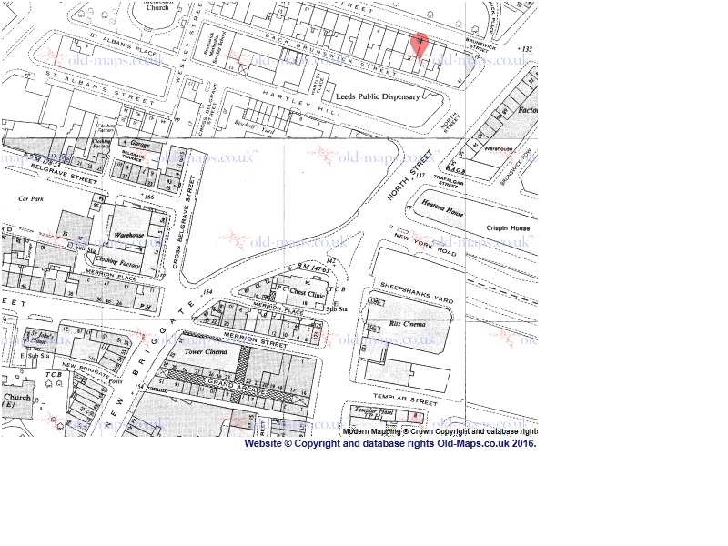
- From a 1962-1990 map in the Old Maps UK website.
- OMUK1962-1990.jpg (168.83 KiB) Viewed 6056 times
Re: Rothwell's Parade, New Briggate
Posted: Mon 07 Mar, 2016 4:02 pm
by volvojack
http://www.secretleeds.com/download/fil ... ew&id=9462
As you can see the Parade is opposite he Chest Clinic, (junction of Vicar lane and Briggate. The road to the right with Heatons (Dome) tailoring factory on the opposite corner is New York Road.
Re: Rothwell's Parade, New Briggate
Posted: Mon 07 Mar, 2016 4:06 pm
by volvojack
It makes me sad looking at this picture to see all the buildings over such a wide area that were swept away to create the Inner Ring Road................. but that's progress I suppose.
