Burley Bar Stone - and the rest
-
LS1
- Posts: 2185
- Joined: Mon 23 Jul, 2007 8:30 am
Geordie-exile wrote: LS1 wrote: Geordie-exile wrote: This 'cladding' looks different to what's there now. Deffo the same Geordie. Are you sure? They appear to be larger panels, with the division around head height, as is the potential plywood. What's there now [or what I can discern on streetview] appears to be half the size. Might be the camera angle I suppose? Think it is the angle of the camera. The chap with the beard is is stood partially down the hill of Lady Lane so things in the foreground look a lot larger than they are. That piece of wood that is there is very weathered!
-
jim
- Posts: 1898
- Joined: Sun 17 May, 2009 10:09 am
jim wrote: Cnosni's post above set me thinking along another tack on this topic. We have been assuming that the bar stones are mediaeval in origin. As Cnosni says,they don't appear to be as old as that. Also, looking at the c1500 map posted by Jogon on 23/1/13 (foot of page 3), the sites are indicated, yet there are no buildings shown near them. I have another theory (cries of "Oh, no!). Could these markers have been put into place as formal markers at the start of turnpike trust toll roads? From the late 17thC to the mid 19thC large numbers of roads were turnpiked by Act of Parliament in a similar way to that used to build railways and canals in the next waves of transport provision. This is not a field in which I have much knowledge, but it would seem quite within reason to start such route from the accepted earlier boundaries of towns and cities. A cursory look at the lists of local turnpike trusts shows that those listed starting from Leeds could well have been from the bar stone sites.As a matter of semantics, I would find the use of the term bar stones more likely to refer to toll bars than the type of bar found at York i.e. gates and or archways at city walls. As turnpike trusts were generally individual private speculations it could also provide a reason for the differences in shape and lettering style to be seen in the surviving stones. The various references to the stones being "at the mediaeval boundaries" do not make the claim that the stones were installed at that time. EDIT These ideas are firmly squashed by my locating several sites of the turnpike limits and toll bar chains/gates/etc on the Godfrey reprints of the 1847 OS maps. An excuse for another thread perhaps.
-
chameleon

- Site Admin
- Posts: 5462
- Joined: Thu 29 Mar, 2007 6:16 pm
Leodian wrote: chameleon wrote: There are so many arguments developed here about the location and all well supported.As I think I posted very early on, my memory is of seeing in the wall at the top of the steps leading up from the bus station, albeit that I thought I recalled it on the opposite pillar to the one in the brickie pic, and remember then investigating its purpose. That ill have been in the 70's.The quote Mark has included suggests it was situated at No 104. I think the numbering convention is that they start at the end which can be described as closest to the city centre. That would suggest that the wood-cladded end could be No 100 with the distant end (next to the café) being 104 where the picture suggest the stone was incorporated. Hi chameleonHaving a check when I was passing by later on this morning the door at the premises on Vicar Lane at the Lady Lane junction is marked 102-104. I think a number of us must have been looking around there recently. Then it is likely the numbers may refer to the individual premises above then, just to add to the confusion!
Emial: [email protected]: [email protected]
-
Phill_dvsn
- Posts: 4423
- Joined: Wed 21 Feb, 2007 5:47 am
cnosni wrote: The St Marys catholic chapel opened in 1794 is the old BRS building (which still exists, grade 2 listed) on Lady Lane, and not the St Marys chantry chapel on North Street associated with the North Bar stone which we are talikng about. Thanks for clearing the St Mary's info up Csnosi.I had thought the 1794 date wasn't as old as it should be. But when it said 'site of' on the old map. I thought a later church was built on the spot that replaced the old Chantry Chapel. The 1794 church (which turned out to be the BRS building further down)Somethings are just far too old to have been recorded properly.This Chantry Chapel seems to be one of them LS1 wrote: Phil - re your other post, it's not felt that is there but it looks like a cheapo green granite that is on the corner edge of the old bus station. If you get a chance to look, wonder what you think it may be or anyone else that has a bit of expertise on stone/ brickwork. Hi Lee.I do know what those sheets are, if it wasn't ply it was always going to be a rock board type of panel. The pebble dash types most commonly seen on garages. I only fixed them once on a school renovation job in the early 90's. It comes in different sizes, colours and textures. The reason I thought it was only plywood is because it looks such an untidy abomination and has done on all the photo since the 70's. I found it hard to believe that was a finished job and not some 'temporary' hoarding. We all know 'temporary' or 'short term' in Leeds can range anything from 30-50 years. I always remember one of the old tradesman saying 'If you can't hide a joint-then make a feature of it' And that's how those sheets were specified to be fixed when we did them. A rubber waterproof black gasket strip was fixed at the back of the sheets. The sheets fitted with an inch gap all around. The finished result was very neat and tidy. It just looked like evenly fixed panels with an inch black surround between them. The panels on those bus station photos look truly awful as they do.
My flickr pictures are herehttp://www.flickr.com/photos/phill_dvsn/Because lunacy was the influence for an album. It goes without saying that an album about lunacy will breed a lunatics obsessions with an album - The Dark side of the moon!
-
mhoulden

- Posts: 412
- Joined: Fri 27 Nov, 2009 8:00 pm
- Location: Wortley
- Contact:
I did a quick Google for "St Marys Chantry Leeds" and found this book: http://books.google.co.uk/books?id=j7QH ... &q&f=false. The Chantry of St Mary Magdalan was at the northwest corner of Briggate (probably where Clas Ohlsen is now) and was founded in 1370 by William Evers. Near the north bar was the chantry of Our Lady. The last priest there was called (Rev?) Bradley who died in 1563 and the chantry was worth £8 13s per annum. There were Abolition of Chantries Act passed in 1545 and 1547 but it took a while for them to be enacted and I'm guessing the people who funded them found ways of delaying their particular chantry from being confiscated until they had been wound down and there was nothing to seize.At some point after 1563 I think the Our Lady's chantry building will either have been rededicated or rebuilt as St Mary's, but this is just a guess on my part.
-
LS1
- Posts: 2185
- Joined: Mon 23 Jul, 2007 8:30 am
Jogon wrote: Oct 1980"Entrance" from Vicar Ln was down a flight of stairs - left of photo where Red Bus Stn joins taller one.Otherwise you walked down Lady Ln round the corner into it.So when disposed of to ?Ogden Properties the building must have been hacked around to create retail at street level Vicar Ln.The question is then whether the stone was at corner Lady Ln/Vicar Ln or by the (now removed) flight of stairs down at the former "Entrance".It might be behind the shop frontages.These all ought to be in the museum, I think. [ps Ctrl + buttons to magnify view, Ctrl - to go back] Anyone got a better quality version of this photo? there is something lighter at the join of the two buildings on the left... Could this be it?
-
Phill_dvsn
- Posts: 4423
- Joined: Wed 21 Feb, 2007 5:47 am
Yes I've played about with that photo too. It's the best one we have. The trouble is with small photos that if you blow them up they just get ruined. I've done the best I can with this photo.There is something on that corner, but it does look very narrow. It could have even bedded inside the stairs entrance. It wasn't laid inside the entrance was it? It would make sense putting it under cover and protecting it from the elements.I've marked the width of the bus station pillar on the right, and the bottom part of the pillar we can't see on the car.
My flickr pictures are herehttp://www.flickr.com/photos/phill_dvsn/Because lunacy was the influence for an album. It goes without saying that an album about lunacy will breed a lunatics obsessions with an album - The Dark side of the moon!
-
mark1978
- Posts: 143
- Joined: Thu 28 Feb, 2013 7:28 am
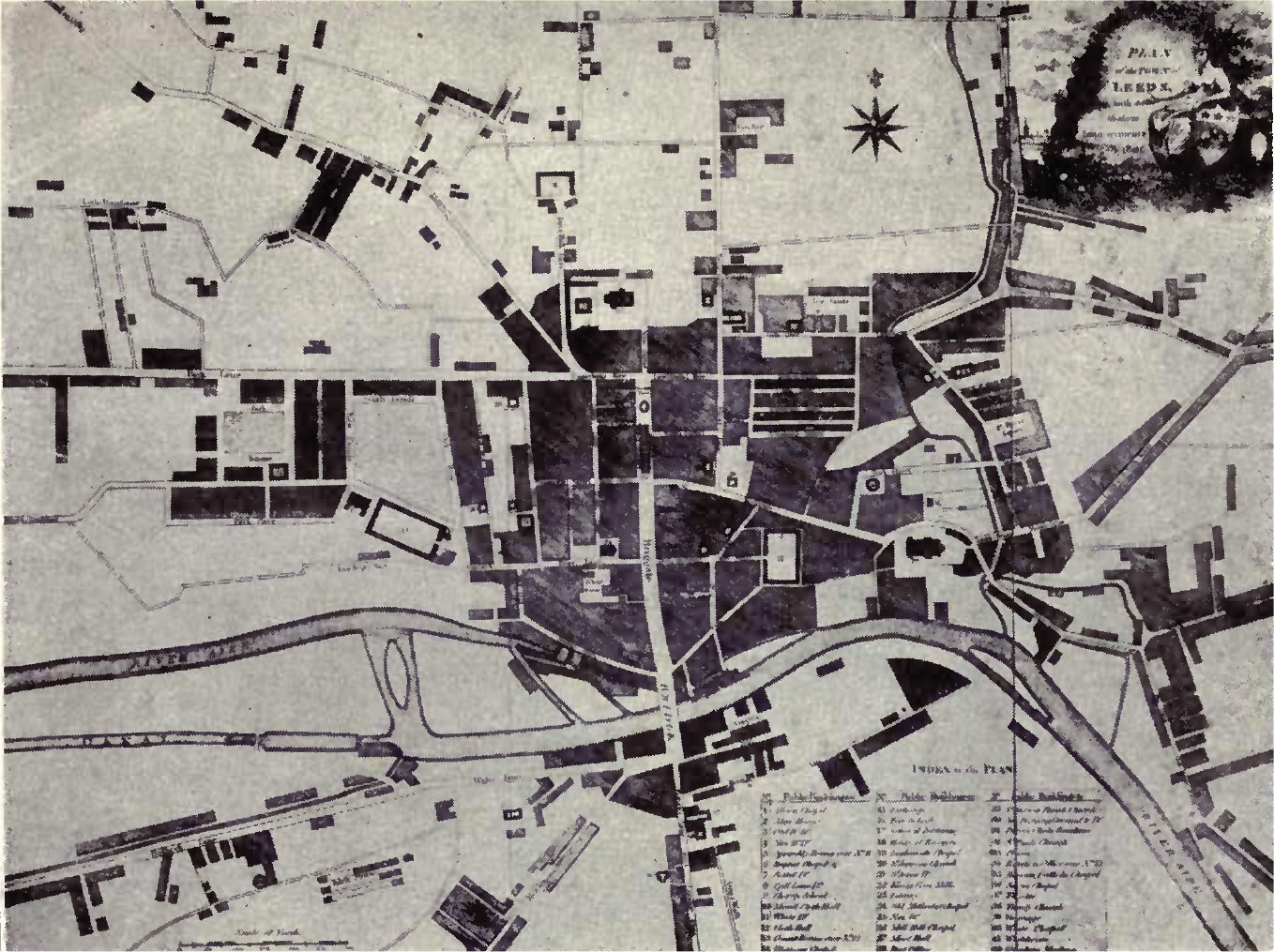
Going off on a bit of a tangent here, but just some additions from a map/chapel perspective.There is a 1560 map at http://upload.wikimedia.org/wikipedia/c ... p_1560.jpg (rotated 90 degrees from what we'd normally expect, ie north is on the left) but the quality's so bad I can't get much sense out of it. There's a redrawn version on Leodis at http://www.leodis.net/discovery/images/ ... 369081.jpg which doesn't tell us much.Here's a detail from the 1725 Cossins map:That bit of Vicar Lane is apparently known at this point as "Town and New Castle Rd" (anyone know what the "New Castle" referred to is?). The only building shown is the workhouse on the corner of Lady Lane (it says at http://www.workhouses.org.uk/Leeds/ that the workhouse was first opened in 163 . No mention of the Chantry and, more oddly, no mention of the bar stone considering Burley Barr gets a mention at the other end.Then there's the 1770 map:The workhouse appears to have grown or been rebuilt, and the road is now called Towns End. There may be some tiny speck on there to indicate the bar stone but I can't really make it out.An 1781 map on Leodis tells a similar story:It would be nice to have the key to this one as the letters presumably indicate something.There's a detailed map from 1806 at http://upload.wikimedia.org/wikipedia/c ... p_1806.jpg but again the quality's so horrible it's not worth bothering with. A better quality version might tell us something - can anyone help?Finally here's a marginally better quality version of the 1847 map:
-
mark1978
- Posts: 143
- Joined: Thu 28 Feb, 2013 7:28 am
Phil, the possibility that the stone was mounted inside the bus station entrance is a very good shout. It also fits with the suggestion from the WYAS that it's behind a plywood facade- not the hoarding on the Lady Lane corner, but the white shopfront next to the Hellenic. The plot thickens.On the subject of the Lady Lane corner (seeing as I don't think we've ruled that out) anyone know what's going on in these two pics from 1999?Duff quality, but it looks like the corner is being used as a poster hoarding at that point. So still possible that the bar stone is behind there somewhere.